Places To See
 Tammin Hydrology Model And Amphitheatre - Kadjininy Kep
Features a working model depicting a typical wheatbelt landscape showing how farming land is being lost to salinity – and some solutions.
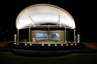
(Outdoor entertainment centre)
Amphitheatre for outdoor concerts, theatre and seminars. Shady grassed area’s with BBQ facilities available for day trips or when passing through.
Charles Gardner Reserve
An area of 600 hectares of natural vegetation 14kms south of Tammin. It contains a wide variety of wildflowers and understorey, some of which are unique to the region.
Yorkrakine Rock
Situated 26kms north of Tammin is a solid granite outcrop 341m high and covering 160 hectares. A strip of native flora surrounds the outcrops which is one of the largest of its kind in WA. It is another important haven for native flora and fauna.
Hunts Well
Once used as a watering point for prospectors and others en route to the Goldfields.
One of many wells named by surveyor Hunt. Picnic tables on-site for travellers.